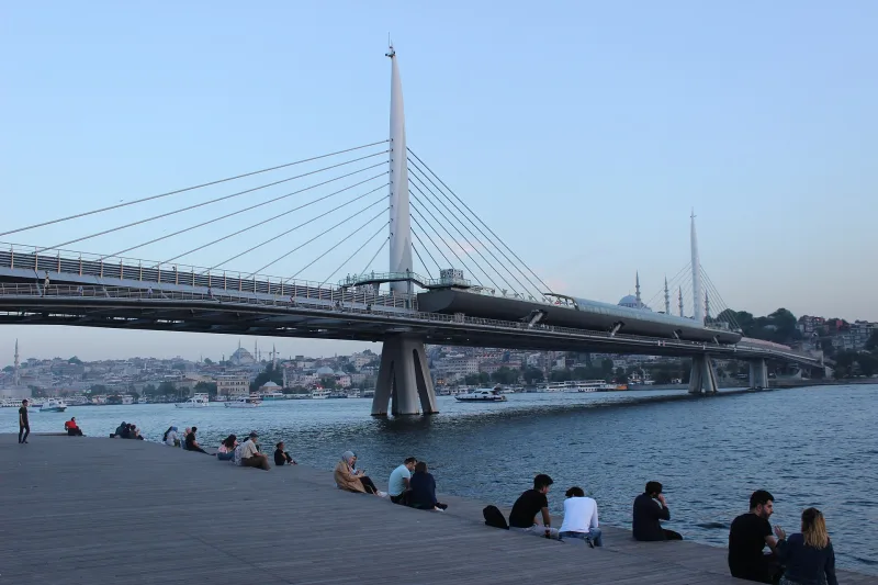
The Golden Horn—a cable-stayed metro bridge that has transformed Istanbul’s skyline
The Golden Horn Metro Bridge (Turkish: Haliç Metro Köprüsü) is the most controversial and, at the same time, one of the most recognizable engineering structures in modern Istanbul. It is a cable-stayed bridge that has carried the M2 line of the Istanbul Metro since February 15, 2014, crossing the bay of the same name between the districts of Beyoğlu and Fatih on the European shore. The Golden Horn Bridge became the fourth structure spanning the bay, situated directly between the historic Galata Bridge and the Atatürk Bridge—just 200 meters east of the latter. Its design was accompanied by a threat from UNESCO to remove the city’s historic center from the World Heritage List, and the final silhouette—with 65-meter-high “horn”-shaped pylons and a station directly above the water—became a compromise between transportation needs and the ancient urban landscape.
History and Origin of the Golden Horn
The idea of building a special bridge for rail transport across the bay had been floating around Istanbul for a long time. The first design sketches date back to 1952, and Turkish Wikipedia reports that the project’s development traces its roots to the 1960s. However, for decades the plan remained on paper: crossing the Golden Horn required not only an engineering solution but also compliance with the protected status of the historic center of Constantinople-Istanbul. The idea only began to take shape during the tenure of Mayor Kadir Topbaş (2004–2017).
After the new metro line received approval from the city council’s heritage preservation committee and the metro tunnels on both banks had already been excavated, the municipality announced a design competition. By 2005, twenty-one designs had been submitted for review, but none fit into the silhouette of the old city. The winning design by Turkish architect Hakan Kiran remained the subject of fierce controversy: UNESCO officials directly threatened to remove Istanbul from the World Heritage List if the towers were too tall.
In November 2009, the height of the pylons was reduced from the planned 82 to 65 meters. The upper level of the cable attachments was lowered from 63 to 55 meters, and then in 2011—to the final 47 meters. The revised design was approved in February 2012. The conceptual design was led by French bridge engineer Michel Virloje, the designer of the third bridge across the Bosphorus named after Sultan Selim the Grim. Hakan Kiran was responsible for the architectural design and project supervision, while engineering calculations were performed by Wiecon Consulting Engineers & Architects. Construction was undertaken by a consortium of the Italian firm Astaldi and the Turkish firm Gülermak Ağır Sanayi İnşaat ve Taahhüt A.Ş.
Work began on January 2, 2009, and was scheduled to last 600 days. In reality, construction took longer: completion was dated January 9, 2013, test trains ran the very next day, and regular service began on February 15, 2014. The total cost was 146.7 million euros. During construction, the project was revised twice due to archaeological discoveries: while digging foundations for supports on the Unkapana-Küçükpazarı side, a Byzantine vault was discovered, followed by the remains of an early Christian basilica wall and a cemetery. The design of the drawbridge operator’s building also had to be revised.
Architecture and What to See
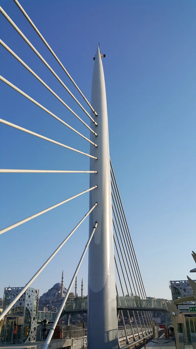
From an engineering standpoint, the Golden Horn Bridge is a cable-stayed bridge 936 meters long, 460 meters of which span the water between the shores of Azapkapi (Beyoğlu) and Unkapana (Fatih). The main span between the two towers is 180 meters, with nine cables on each side in a harmonic configuration, anchored at a height of 47 meters. The steel pylons rise 65 meters and, according to Hakan Kiran’s design, are specifically shaped to evoke the silhouette of a ship’s horn, while the platform supports resemble ship hulls. This is a direct reference to the city’s maritime past.
Foundation on Soft Soil
The bottom of the Golden Horn consists of soft, silty sediments, so dozens of steel tubular piles with diameters of 1,800 and 2,500 millimeters, imported from Europe, had to be driven beneath each tower. They were driven to a depth of over 30 meters using a hydraulic hammer. Each tower stands on a group of nine piles, while the side supports rest on groups of four or five. It is this hidden part of the work that ensures the stability of the entire structure in a seismically active region.
Platform, sidewalks, and movable span
The bridge is 12.6 meters wide. Two subway tracks run down the center, with two sidewalks, each 4.4 meters wide, on either side. The deck is raised 13 meters above the water, and the box-girder superstructure itself is 4.45 meters high. On the Unkapana side, there is a 120-meter bascule span—a cantilever structure with 50- and 70-meter sections supported by a central pier. The opening is controlled from a separate control room between the bridge and the shore: the span rotates at a right angle around a vertical axis and opens a channel about 40 meters wide in four to six minutes. In the summer, the span is opened once a week from 1:00 a.m. to 5:00 a.m.; in the winter, twice.
Haliç Station — a subway station over water
The main architectural highlight is the 180-meter-long “Haliç” station, which is built directly into the central span over the bay. The platform is designed for an eight-car train and is covered by a 90-meter-long canopy. According to plans, up to one million passengers will pass through the station and the bridge daily, connecting the Taksim district with historic Sultanahmet, the Grand Bazaar, and the Yenikapı transportation hub. For travelers, this means one simple thing: you can step off the subway train right above the water, see the Galata Tower to your right and the silhouette of the Süleymaniye Mosque to your left, and capture one of the most unique cityscapes in Istanbul.
Viaducts and Connections to Tunnels
On both sides, the bridge transitions into viaducts that smoothly guide the M2 line into underground tunnels. On the north side—toward Şişhane and further to Taksim and Hacıosman; on the south side—toward Vezneciler, Yenikapı, and toward Sabiha Gökçen Airport via transfers. It is precisely thanks to these viaducts that the bridge does not simply “hang” over the bay, but organically becomes part of the 60-kilometer underground corridor.
The Debate Over the Old City’s Skyline
Even after the height was reduced, the debate over the architecture did not subside. The Turkish Chambers of Architects and Urban Planners, as well as many city residents, criticized the authorities for altering the UNESCO-approved plans during construction without prior approval. Critics insisted that any interference with the historic panorama of Sultanahmet, the Süleymaniye Mosque, and the Galata Tower was unacceptable. Supporters of the project countered that a city with a population of 15 million still needed modern infrastructure, and that the pylons, despite all the complaints, were less intrusive than elevated highways. After the metro opened, the wave of criticism subsided noticeably: the Haliç station and pedestrian walkways significantly improved access between the shores for those without cars, and the bridge itself gradually became part of Istanbul’s everyday landscape.
Interesting Facts and Legends
- The idea for the bridge was conceived as early as 1952, but it waited over half a century to be realized—a rare case in urban engineering where more than 60 years passed between the blueprint and the opening.
- In 2009, UNESCO directly threatened to remove historic Istanbul from the World Heritage List unless the height of the pylons was reduced. This is the only instance in the city’s modern history where intervention by an international organization altered an engineering project during the construction phase.
- While excavating the foundation pit for a support pillar on the Unkapanı side, archaeologists discovered a Byzantine vault, followed by the wall of an early Christian basilica and an ancient cemetery. The project had to be redesigned twice—thus, Byzantium literally “stopped” Italian and Turkish builders in the 21st century.
- The concept’s author, Michel Virloje, also designed the third bridge across the Bosphorus, named after Sultan Selim the Grim—in fact, this single man largely shaped Istanbul’s modern bridge skyline.
- Turkish residents nicknamed the pylons “horns” (Turk. boynuz)—a reference both to the name of the “Golden Horn” bay and to the maritime symbolism that architect Hakan Kiran incorporated into the towers’ design.
- After the opening of the Haliç station, many residents of the surrounding neighborhoods were able to cross the bay without a car for the first time: until 2014, car owners used the Atatürk Bridge, while pedestrians had only the Galata Bridge.
How to Get There
The easiest way to reach the Golden Horn Metro Bridge is via the M2 line of the Istanbul Metro. The station is called Haliç and is located right in the middle of the span over the water—you can’t miss it. Trains come from the north via Hacıosman (Sarıyer district) through Taksim and Şişhane, and from the south via Yenikapı through Vezneciler. From Sultanahmet, the most convenient option is to take the T1 tram to Karaköy or Eminönü and transfer to the M2 at Şişhane, from where it’s just one stop to Haliç.
From Istanbul Airport (IST), take the M11 metro to Kâğıthane, then the M7 to Mecidiyeköy, and the M2 toward Yenikapı. From Sabiha Gökçen Airport (SAW), it’s easier to take the Havabus express bus to Taksim, where you can transfer to the M2. If you want to see the bridge from the outside, head down to the waterfront at Ünkapı or Azapkapı: from here, you’ll get a front-row view of the pylons and cables. Another option is to take a Vapur sightseeing boat along the Golden Horn from the Eminönü pier: the route passes directly under the bridge, and this is the best way to appreciate its scale.
Tips for travelers
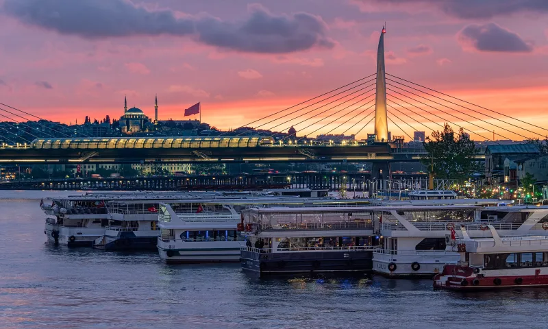
The best time to visit is at sunset in spring and fall, when the low sun illuminates the steel cables, and the Haliç station platform offers a double panorama: to the west—the Süleymaniye Mosque and the Old City; to the east—the Galata Tower and the Karaköy neighborhoods. In summer, the July heat and dense crowds in the metro can be stifling; in winter, frequent rain and the wind over the bay make a walk along the outer sidewalks chilly, but the pylons’ lighting at dusk becomes even more striking.
Allow 30–40 minutes for the bridge itself if you limit yourself to the station and the two sidewalks. For a full experience, plan 1.5–2 hours: a walk along the Ünkapı Promenade, coffee at a waterfront café, a photo session of the pylons, and the return trip by metro. Russian-speaking tourists will find the Istanbulkart travel pass convenient: it’s accepted on the M2, the T1 tram, shuttle buses, and ferries, and can be reloaded at vending machines at every metro entrance. Bring water, sunscreen in the summer, and a windproof jacket during other seasons—the wind over the Golden Horn is noticeably stronger than in the sheltered streets of Galata.
Combine your visit with nearby attractions: the Galata Tower (a 15-minute walk from Şişhane station), the Süleymaniye Mosque (20 minutes from Vezneciler station), the Egyptian Bazaar, and the New Mosque in Eminönü. For Russian-speaking travelers accustomed to the scale of St. Petersburg’s bridges across the Neva, the comparison is particularly interesting: despite a similarly striking cable-stayed design, the Golden Horn Bridge is intentionally “huddled” close to the water so as not to interrupt the silhouettes of the domes and minarets of the old city—it is precisely this compromise that constitutes its main architectural concept. Another convenient option is to combine your visit with the bridge’s opening. Unlike in St. Petersburg, where bridges open regularly and on schedule, the opening schedule here is flexible: once a week in the summer and twice a week in the winter, at night from 1:00 a.m. to 5:00 a.m. It’s best to check the current schedule the day before with the Istanbul Metropolitan Municipality or a guide: exact dates aren’t published in a public calendar. If you’re lucky, you’ll witness a rare sight—the 120-meter cantilever silently rotating to a right angle, opening the bay for cruise ships. A special tip for photographers: return to the bridge during the blue hour immediately after sunset; the illuminated cables against the backdrop of the still-light sky create one of Istanbul’s most iconic modern shots. If you’re traveling with children, keep in mind: the platform is open but fenced off, and the noise from subway trains and passing ships can be noticeable. The Golden Horn as an engineering structure is a rare case where transportation infrastructure becomes a landmark in its own right, and that is precisely why it is worth visiting not just “on the way,” but planning at least one separate sunset on its marble-and-steel line above the ancient bay.